-40%
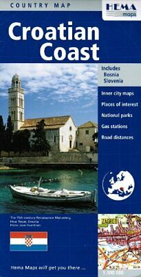
Map of the Croatian Coast, by HEMA Maps
$ 4.19
- Description
- Size Guide
Description
Map of the Croatian Coast, by HEMA MapsRoad and travel map of
the Croatian Coast
with shaded relief and color tints to show the terrain. Distinguishes several kinds of roads from expressways to practicable tracks. Shows road numbers and distances in kilometers. Locates places of interest such as parks, scenic viewpoints, scenic roads, places to stay (including hotels, camp sites and youth hostels). Recommend beaches, Locates spas, swimming pools, forts, airports, ferry lines. Scale 1:300,000. Inset map of
Zagreb
city center. Printed folded paper map with protective hard cover. Large sheet but easy to refold.
The map includes an inset showing an enlargement of Budapest in reasonable detail with important/useful/interesting buildings marked out.
The Hungary travel map features:
City plan of Zagreb
National parks
Places of interest
Road distances
Tourist routes
The map is printed on paper and has a protective coated cardboard cover.
When unfolded, map measures approx. 44" x 36", scale is 1:300,000
Publication date: 2008, ISBN
9781865004808
